Community Data Science Workshops (Spring 2015)/Day 3 Projects/Civic data
From CommunityData


Building and visualizing datasets using data.seattle.gov and Google apps[edit]
In this project, we will explore a few ways to gather data from data.seattle.gov using the Socrata API, the Google Maps API, and Google Fusion tables.
- Today's dataset
- Click here to view the Seattle Building Permits database
- Today's scripts
- Click here to download the today's scripts
Goals[edit]
- Collect data on building permits in Seattle, by neighborhood and by year awarded.
- Combine those data with neighborhood data from the Google Maps API
- Download the results in a CSV file
- Upload results to Google's Fusion Table visualization engine
Topics we will cover[edit]
- creating API queries and filtering and grouping the results
- combining results from multiple APIs
- downloading API results as CSV files
- building visualizations of timeseries and geolocated data
Questions we will (attempt to) answer with our data[edit]
- which Seattle neighborhoods have had the most multifamily residential construction (apartments and townhomes) since 2010?
- how much has the rate of apartment construction increased since 2010?
- where are the most expensive construction projects currently being built?
Other questions you can answer with these data[edit]
- which Seattle developer has built the most apartments and townhomes since 2010?
- where in Seattle are the most single-family homes being constructed?
Resources[edit]
If you are confused by anything today, go back and refresh your memory with the Day 0 setup and tutorial and Day 0 tutorial
- Sample API queries
- Building permit data: https://data.seattle.gov/resource/mags-97de.json?$where=issue_date%20IS%20NOT%20NULL%20&action_type=NEW&category=MULTIFAMILY&$limit=100
- Google maps location (using street address): http://maps.googleapis.com/maps/api/geocode/json?address=5601+22ND+AVE+NW+Seattle+WA
- Google maps location (using lat/long): http://maps.googleapis.com/maps/api/geocode/json?latlng=47.66979666%2C-122.38570052
- Sample charts/maps
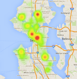
- Google Fusion table map of permits 2010-2015 [1]
- Help resources and inspiration
- About Google maps API: https://developers.google.com/maps/documentation/geocoding/#ReverseGeocoding
- About Google Fusion tables: https://support.google.com/fusiontables/answer/2571232
- Google Fusion Tables mapmaking tutorial: https://support.google.com/fusiontables/answer/2527132?hl=en&topic=2573107&ctx=topic
- API sandbox tool: https://www.hurl.it
- API-powered app: http://web6.seattle.gov/mnm/
- Socrata API help resources: http://dev.socrata.com/consumers/getting-started.html
- filtering results: http://dev.socrata.com/docs/filtering.html
- dealing with timestamps: http://dev.socrata.com/docs/datatypes/timestamp.html
- writing API queries: http://dev.socrata.com/docs/queries.html
- Other data.seattle.gov datasets with neighborhood, timeseries, and/or location data
- Seattle Cultural Space Inventory
- MTS trail bike/ped traffic
- Burke Gilman trail bike/ped traffic
- Road temps in Seattle
- SPD 911 incident respose
- Instructional videos
- https://data.seattle.gov/videos
- https://www.youtube.com/watch?v=YlKzXTrTLOQ
- https://www.youtube.com/watch?v=Whfp8ojMf0U
- https://www.youtube.com/watch?v=Vd6bwz3ivVA
- Other Socrata sites that use this API
