Community Data Science Workshops (Fall 2015)/Day 3 Projects/Civic data
Building and visualizing datasets using data.seattle.gov and Google apps
In this project, we will explore a few ways to analyze data from data.seattle.gov using the Socrata API, the Google Maps API, and Google Fusion tables. We'll learn how to visualize new residential construction in Seattle over time, by neighborhood, and by map location using graphs and heatmaps.
Topics we will cover
- Writing and testing complex API queries
- Use Python to read and write CSV files
- Combine data from two different APIs (data.seattle.gov and Google Maps)
- Visualize data using Google's Fusion Table visualization engine
We will also explore an important non-technical part of data science: thinking critically about data. Thinking critically about the data you have, and what conclusions you can draw from it, is especially important when you are visualizing data, because its easy to mislead people with visualizations. We'll discuss how visualizations based on incorrect data can lead people to make false conclusions, using an example from a recent visualization of building demolitions published in the Northwest design magazine Arcade.
Preparation
- Step 1
- Download today's scripts and sample datasets: FIXME
- Today's dataset
- Click here to view the Seattle Building Permits database
Visualizing new home construction in Seattle over time
- Question
- Has the rate of apartment construction increased since 2010?
Visualizing new home construction in Seattle by neighborhood
- Question
- which Seattle neighborhoods have had the most multifamily residential construction (apartments and townhomes) since 2010?
Mapping new home construction in Seattle
- Question
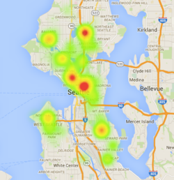
- what locations have experienced the highest density of new construction since 2010?
Challenge questions
Try to answer these additional questions that draw on the data and methods we're learning today. Ask a mentor if you get stuck!
- In which Seattle neighborhood is the cost of new construction projects highest, on average?
- Where in Seattle are the most commercial buildings being constructed in 2015?
- How does the rate of residential construction in Seattle from 2010-2015 compare to the previous 5 years?
- How many townhouses have been constructed in Seattle since 2011?
Resources
If you are confused by anything today, go back and refresh your memory with the Day 0 setup and tutorial and Day 0 tutorial
- Sample API queries
- Building permit data: https://data.seattle.gov/resource/mags-97de.json?$where=issue_date%20IS%20NOT%20NULL%20&action_type=NEW&category=MULTIFAMILY&$limit=100
- Google maps location (using street address): http://maps.googleapis.com/maps/api/geocode/json?address=5601+22ND+AVE+NW+Seattle+WA
- Google maps location (using lat/long): http://maps.googleapis.com/maps/api/geocode/json?latlng=47.66979666%2C-122.38570052
- Sample charts/maps
- Google Fusion table map of permits 2010-2015 [1]
- Help resources and inspiration
- About Google maps API: https://developers.google.com/maps/documentation/geocoding/#ReverseGeocoding
- About Google Fusion tables: https://support.google.com/fusiontables/answer/2571232
- Google Fusion Tables mapmaking tutorial: https://support.google.com/fusiontables/answer/2527132?hl=en&topic=2573107&ctx=topic
- API sandbox tool: https://www.hurl.it
- API-powered app: http://web6.seattle.gov/mnm/
- Socrata API help resources: http://dev.socrata.com/consumers/getting-started.html
- filtering results: http://dev.socrata.com/docs/filtering.html
- dealing with timestamps: http://dev.socrata.com/docs/datatypes/timestamp.html
- writing API queries: http://dev.socrata.com/docs/queries.html
- Other data.seattle.gov datasets with neighborhood, timeseries, and/or location data
- Seattle Cultural Space Inventory
- MTS trail bike/ped traffic
- Burke Gilman trail bike/ped traffic
- Road temps in Seattle
- SPD 911 incident respose
- Instructional videos
- https://data.seattle.gov/videos
- https://www.youtube.com/watch?v=YlKzXTrTLOQ
- https://www.youtube.com/watch?v=Whfp8ojMf0U
- https://www.youtube.com/watch?v=Vd6bwz3ivVA
- Other Socrata sites that use this API


